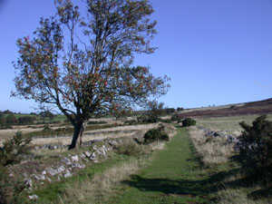
The south Shropshire hills are popular with
walkers, hikers and geologists who, having
discovered the area, tend to return.
Being less well known than other tourist
attractions, the area has retained its rural
beauty, peacefulness and solitude.
A favourite among these hills must be the
Stiperstones. Approximately six kilometres long,
two kilometres wide and rising to 536 metres,
Stiperstones offers superb views over the
surrounding countryside with other South
Shropshire hills lying to the east and south; the
Welsh mountains to the west and the Wrekin,
symbol of Shropshire, to the north east.
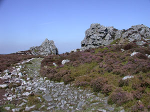
Craggy tors lining the ridge instantly identify
the Stiperstones.
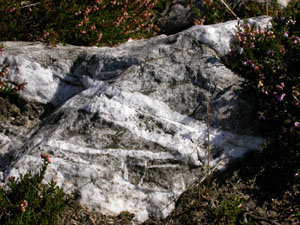
The Stiperstones ridge consists almost entirely
of quartz-arenite sandstone that was deposited
originally in shallow water, littoral or beach
conditions. It was later cemented by quartz in
solution to form the hard quartzite rock.
To the west of the ridge, the Stiperstones
Quartzite Formation is overlain by the Mytton
Flags Formation. The Mytton flags were heavily
mineralised. There is evidence that lead was
mined here by the Romans and that lead (galena),
zinc (sphalerite) and barium (barite) supported a
highly successful industry in the nineteenth and
early twentieth centuries.
In the late 1800s Britain was the largest
producer of lead in Europe and the mine at nearby
Snailbeach had a higher output than any other
mine; accounting for an estimated 10% of UK
output. The Hope Valley, to the west of
Stiperstones was dotted with lead mines, some
very successful, others speculative failures.
Evidence of this industry is still visible today
in numerous spoil heaps, ruined engine houses,
chimneys and capped mine shafts.
Return to Top
The mineralisation of the Mytton Flags has not
been conclusively proved. One theory is that it
may have been due to Scottish granite being
carried south as pollution, dumped in Shropshire
and then deposited in cracks in the rocks by
relatively low temperature (around 100-200
degrees Centigrade) hydro-thermal action.
For a more detailed study of this area it is
recommended that the reader consult the
following:-
-
Geologists' Association Guide No.27 "The
Geology of South Shropshire" by M.�Allbutt,
J.�Moseley, C.�Rayner and P.�Toghill.
-
"The Shropshire Lead Mines" by Fred�Booth and
Martin�Allbutt.
One theory is that Stiperstones was laid
down in the Ordovician as a sandy beach and
that the sand grains were later cemented
together by quartz in solution to form a very
hard quartzite rock.
If this were so one would expect to find, as
evidence of a beach,
-
Pebbles
-
Invertebrate tubes or burrows, and
-
Ripples caused by ebb and flow
Quartz intrusion, pebbles and burrows can be
easily found in the scattered rocks of the
ridge path, as the pictures below show:-
The GA guide No.27 reports that evidence of
ripples is common on bedding surfaces, with
amplitudes of 5 - 10cm and wavelengths of 50
- 90cm, though these may be difficult to
find.
Return to Top

|
|
Quartzite tor south of the Devil's
Chair
�
|
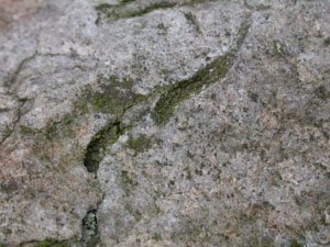
White quartz intrusions into grey
quartzite rock
�
|
|
|
Quartz pebbles
�
|
Bioturbation - tube or burrow?
�
|
Return to Top
Access and Safety
The Stiperstones area is criss-crossed by
numerous public rights of way that enable a
visitor to plan a circular walk. Three car
parks are conveniently placed for vehicular
access, they are:-
Towards the southern end of the northern
ridge,
-
The site of the former Bog Mine (SO 357978)
-
The National Trust car park just north of the
road to Bridges (SO 370977)
and in the north,
-
The Snailbeach village car park (SJ 373023)
Extreme caution is needed when climbing on
the tors. The ridge path comprises scattered
rocks that may move underfoot. The visitor
should note that, even off the ridge path,
heather and whinberry may be growing in only
an inch or two of soil above hard quartzite
rocks.
Some of the batches at the north west end of
the Stiperstones are very steep and can be
slippery in wet weather, as can the numerous
spoil tips from disused lead mine workings