The Sedgwick Geological Trail was created in 1985
to celebrate the bicentenary of the birth of Adam
Sedgwick, a distinguished mathematician,
clergyman and geologist.
Adam Sedgwick was born in the lovely Yorkshire
Dales village of Dent on 22nd March 1785, son of
the vicar of Dent.
Educated at Dent school and Sedberg Grammar
school, Sedgwick went up to Trinity College,
Cambridge, where he graduated with a first class
honours in mathematics in 1808. He was appointed
a fellow of Trinity College in 1810 and was
ordained in 1817, going on to become a canon in
Norwich cathedral.
However, it is as a geologist that he is best
remembered.
In 1819 Sedgwick was appointed Woodwardian
Professor of Geology at Cambridge. Four years
later he made a detailed study of rocks in the
Lake District. In 1829 Sedgewick became President
of the Geological Society of London. Charles
Darwin studied geology under Sedgwick, at
Cambridge, before departing on the 'Beagle' in
1831 as project naturalist. The two men
corresponded regularly and Darwin sent many
geological specimens back to Sedgwick.
He was also a close friend of Roderick Murchison.
They did a joint study of the rocks of Scotland
and, in the early 1830s, they worked together in
Wales. Murchison's work led to his definition of
the Silurian System, while Sedgwick coined the
term 'Cambrian' to define the system of rocks he
studied in mid-Wales. They gave a joint
presentation of their work in 1835. In 1839 they
gave another joint presentation on the rocks in
Devon; a study that defined the 'Devonian System'
(410 to 360Mya).
Their work in Wales led to a dispute between
Sedgwick and Murchison because Murchison's Lower
Silurian and Sedgwicks Upper Cambrian overlapped.
The dispute was finally resolved in 1879 when
geologist Charles Lapworth defined the Ordovician
System, encompassing the disputed time sequence.
Return to Top
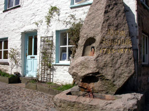
Sedgwick was a great benefactor who never lost
contact with the village of his birth. The year
after he died, the people of Dent erected a
memorial fountain in honour of their most famous
son.
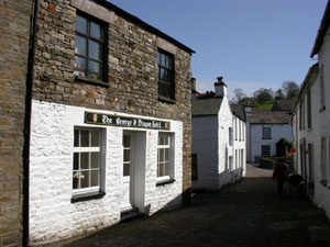
The first picture above shows the 'George &
Dragon' hotel in Dent, a charming village that
still retains its cobbled streets and must be
little changed since Sedgwick's time. The second
picture is of the Sedgwick memorial fountain.
The Trail
The Sedgwick Geological Trail has twelve
exposures marked by numbered wooden posts.
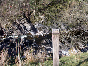
Sites 1 to 4 show Lower Carboniferous limestone,
dating from about 330 million years ago (Mya)
dipping approximately 60 degrees upstream. Site 2
has exposed Coral and Brachiopods indicating that
the beds were deposited in a shallow tropical
sea. At site 3 the limestone beds are separated
by thin beds of shale showing that conditions
were not stable. There had been short periods
when muddy sediments were deposited. Site 4 has
several deposits of black Chert in the limestone
possibly resulting from silicious gel settling on
the sea bed.
Moving westwards between sites 4 and 7 there is
evidence of an anticline followed by a syncline
with the beds at site 7 dipping vertically. This
is evidence of massive crumpling of the beds due
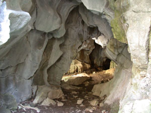
to earth movements. In Tom Croft cave at site 7
calcite has crystallised out on the surface (see
picture below). This is thought to be caused by
heating of the rock, further evidence of massive
earth movement.
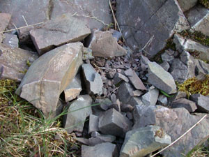
Between sites 7 and 10 there is a marked change
in rock form. Bedded limestone has been replaced
by Breccia. The rock has been shattered into
small pieces by unimaginable forces.
Mineralisation is further evidence of intense
heating. The steep sided, narrow river valley has
also become wider and shallower.
At site 10 a fine grained mudstone (Brathay
Flags), deposited 425 million years ago and
dipping downstream at 62 degrees, has replaced
the limestone. At this site one can also see an
unconformity in which the Brathay flags are
overlaid by a red pebble conclomerate.
Adam Sedgwick was the first person to observe and
explain these features. He attributed them to an
enormous upheaval that raised the Lake district
hills to the west by as much as 2.5Km relative to
the Dales hills in the east. This is now known as
"The Dent Fault".
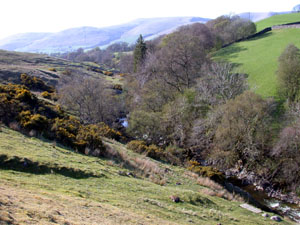
Two general pictures of the trail and six
pictures of selected exposures are shown below:-
Return to Top
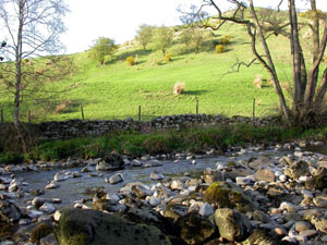
|
|
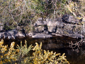
View westwards along the Clough river -
site of the Sedgwick Geological Trail
�
|
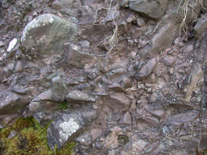
Site No.2 - Corals and Brachiopods indicate
that these rocks originated in a warm
tropical sea
�
|
|
|
Site No.5 - Anticline caused by upthrust of
Silurian Lake District rocks to the
west
�
|
Site No.7 - Tom Croft Cave showing calcite
crystallised out on limestone by heat
�
|
Return to Top
|
|
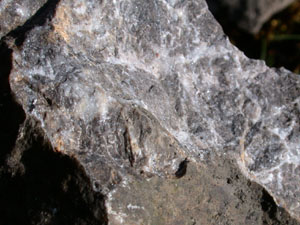
Site No.9 - Shattered and mineralised
limestone, further evidence of heating
�
|
Site No. 10 - Brathay Flags downstream of
the Dent Fault are Silurian mudstone that
was uplifted by as much as 2.5Km
�
|
|
|
Site No. 11 - Conglomerate deposited above
the Brathay Flags in a desert
environment
�
|
Approximate line of the Dent Fault (looking
north) between Sites 9 and 10
�
|
Return to Top
Maps and Guides
-
Ordnance Survey Landranger 98 - Wensleydale &
Upper Wharfedale, 1:50,000 scale
-
Ordnance Survey Explorer OL19 - Howgill Fells&
Upper Eden Valley, 1:25,000 scale
-
Sedgwick Geological Trail, A landscape trail in
the Yorkshire Dales National Park
An excellent, detailed guide, based on
information provided by Dr.R.B.Rickards, and
published by the Yorkshire Dales National Park
Authority
Access and Safety
The Sedgwick Geological Trail is 3.5Km east of
Sedbergh on the A684 Sedbergh to Hawes road.
There is a large gravelled car park (SD 695913)
on the north side of the road at the crest of a
hill adjacent to the viewpoint shown on the
Ordnance Survey maps. A well made path descends
from the car park to the Clough river valley.
Turn left just before the bridge across the river
to enter the trail.
The trail has twelve exposures marked by numbered
wooden posts. The trail is on private farmland so
visitors are requested to keep to the marked
footpaths
Note: The river bank is steep and can be
slippery when wet. Special care must be exercised
when clambering onto rocks in the river. Some are
unstable and all can be very slippery when wet.