On a bright sunny day seventeen of us, KGG members, friends and
colleagues of Dr Adrian Rundle from the Natural History Museum,
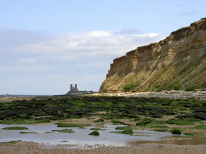
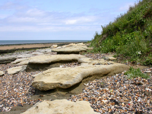
met Adrian at Herne Bay for a field meeting. Our intention was
to study the geology of the Palaeocene and Eocene rocks exposed
in the cliff faces and on the foreshore between Herne Bay and
Reculver to the east (see the picture left with the towers of St
Mary's Church, Reculver on the skyline).
These rocks were deposited between fifty two and sixty million
years ago, when the area was beneath a shallow sea and several
degrees nearer to the equator. They range from coarse grain sands
to fine clay.
Starting from the oldest and lowest beds the exposed formations
are the Thanet Sand Formation, the Upnor Formation, the Oldhaven
Formation and the London Clay Formation.
Topping these formations are recent Brickearth (wind blown) and other
drift deposits. Though described as 'rocks' the cliffs still comprise
loosely consolidated deposits that make them unstable and subject
to serious erosion. The Oldhaven, Upnor and Thanet Sand Formations
all sit unconformably on earlier deposits as other formations
in the sequence are either absent or have been eroded away.
Adrian had planned the field trip well. Starting at 10.30am with
high tide at 8.02am and low tide at 1.55pm we had about three
and a half hours of receding tide - plenty of time to do all
that we wanted.
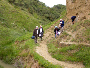
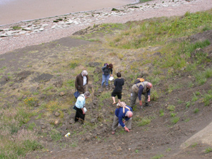
Our first stop was Bishopstone Glen (see picture right), a cleft
running back into the cliff, where the sequence from Thanet Sand
Formation to London clay was visible. The Thanet Sand is above
beach level but is mostly obscured by material from cliff falls
and sea defence works. This site is of international importance
and protected. Climbing or digging the faces is prohibited.
Studying a small sample of grey sand with a lens showed that it
consisted of sharp, glassy grains with dark green/black specks.
The glassy grains were quartz and the dark specks were glauconite.
Glauconite is an iron/potassium silicate formed by chemical and
biological alteration of iron-rich micas in slowly depositing
sediments. It is indicative of a continental shelf environment.
Glauconite is the mineral that gives the Wealden Greensand its
colour and name.
Return to Top
Further up the cliff face were several burrows made by solitary
bees. Adrian explained that these bees paralyse their prey before
carrying it into the burrow. The bee then lays eggs on its victim
before sealing it up in a nursery/tomb!
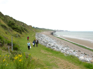
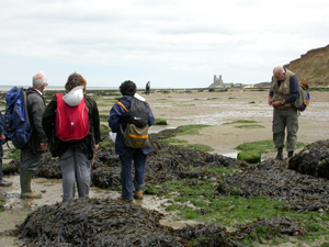
From the Glen we moved eastwards towards Reculver, noting the
exposed strata as we did so. The cliffs are constantly being
eroded, partly by waves under-cutting the soft sandstone and partly
by water filtering down through the cliffs and washing out the less
consolidated sediments. Large blocks of Norwegian Larvikite
have been placed at the top of the foreshore to reduce wave erosion of the
cliffs (see picture left).
The stratigraphy here was defined by D. J. Ward in 1978 (see
references below). Ward divided the formations into sixteen units,
the Thanet Sand Formation - units A (oldest) to I, the Upnor
Formation - units J and K, the Oldhaven Formation - units L to N,
and the London Clay Formation - units O and P.
It is very difficult to identify these units from the foot of
the cliffs, but helpful clues allow one to trace the major formations.
The lowermost Thanet Sand Formation is mostly glauconitic grey-green
silty sand. The easiest to identify is bed 'B' that consists mainly
of large flat tabular nodules. These are best seen towards the Reculver
end of the beach where the tablets project outwards from the cliff
face. Most of the other beds are defined by the fossils they contain
viz.,Artica eutylus cuneatus (A), Artica morrisi (C),
Panopea remensis (D), Astarte tenera (E), Tornatellaea
parisiensis (F), and Corbula regulbiensis (G). Some
readers may be interested to know that 'regulbiensis' means 'of
Regulbium', Regulbium being the Roman name for the place we know
today as Reculver.
The top of the Thanet Sand is perhaps most easily identified by the
lower bed (J) of the Upnor Formation that lies above it. Known as the
Beltinge Fish Bed, this is a dark silty clay with rounded black
pebbles and numerous sharks' teeth.
The division between the Upnor and Oldhaven Formations may be identified
by the Oldhaven Basal Pebble Bed (Unit L). This unit comprises
small rounded black flint pebbles in a sandy matrix. The pebble bed
is very distinct, where it occurs, and may be traced along much of the
cliff face.
Some time was spent looking for fossils and selenite crystals in the
fallen scree at the foot of the cliffs. Before lunch the party examined
the Artica morrisi Bed and Artica eutylus cuneatus Bed
on the foreshore. Samples of the latter were collected for the microfossils.
The party then had lunch sitting on some rock tablets before making
its way back along the beach. A further look at the Artica morrisi
Bed in its scattered exposures on the foreshore towards Herne Bay
yielded pyritic internal moulds of some of the bivalves. Samples
of Recent fine shelly sand concentrated next to the groins were
collected for foraminifera etc. We ended up on the pebble spit,
that is exposed at low tide, on which sharks' teeth derived from
the Beltinge Fish Bed can be found. Looking for sharks' teeth
proved to be a popular pastime.
A few pictures of the group's activities are shown below:-
Return to Top
|
|
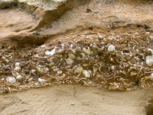
A lens of bivalves in the Oldhaven Formation in the cliff face, mostly badly eroded and very fragile
�
|
Large tablets of sandstone washed out of, or eroded from, the Thanet Sand Formation
�
|
|
|
Some members of the group searched for fossils in the scree at the foot of the cliffs...
�
|
While others preferred to get muddy on the foreshore
�
|
More pictures
For more pictures of the field trip click here
All pictures were taken by Stephen Taylor
Return to Top
Access
There is a fast, half hourly train service from London Victoria
to Ramsgate and Dover Priory that stops at Herne Bay. The train
divides at Faversham; usually the front four coaches go to Ramsgate
(via Herne Bay) and the rest of the train continues to Canterbury
and Dover. Be sure to travel in the correct portion of the train
or you could end up in Dover! From the station, follow the visitor
signs to 'The Seaside' until you come to the concrete promenade.
An easy, flat, one and a half miles walk takes you to the end of
the promenade and the start of the geological exposures.
If travelling by car, there is a car park at the end of Reculver
Drive (O/S grid ref: TR 205686) with a concrete path leading down
to the end of the promenade. Alternatively, one may park at
Reculver (where there is a visitor centre and restaurant serving
hot meals) and walk across the downs or descend to the beach
to approach the geological site from the east - a pleasant walk
if the weather is fine!
Safety
Tides can make sea coasts dangerous. Never walk along a seashore
without first checking the times of high and low tides. Always
allow ample time for the journey, including extra time for
unforeseen emergencies.
Seaweed on the foreshore rocks makes them very slippery and may
conceal uneven surfaces. Steps covered with wet clay will also
be very slippery.
References
WARD D.J. 1978: The Lower London Tertiary (Palaeocene) succession
at Herne Bay, Kent. Report of the Institute of Geological
Sciences, No.78/10, 12 pages, 1 figure, 1 map.
DOWNER Geoff. 2011: The Geology of Reculver Country Park.
Published by GeoConservation Kent (formerly Kent RIGS), 53 pages,
many photographs, maps and figures, in colour.
PITCHER W.S. 1967:Itinerary VII, North Kent Coast - Herne Bay.
In PITCHER W.S., PEAKE N.B., CARRECK J.N., KIRKALDY J.F. and HANCOCK J.M. Geologists' AssociationGuides No.30B
RAYNER David, MITCHELL Tony, RAYNER Martin, and CLOUTER Fred.: London Clay Fossils of Kent and Essex.
Published by the Medway Fossil and Mineral Society, 228 pages, 1270 photographs and 265 named species.