This walk was aimed primarily at the younger
members, though there was plenty for the older
members to enjoy.
Before starting the walk we returned to the
Westminster Bridge where Ann introduced the
younger members to the game of 'pooh sticks'.
This was not a trivial pursuit, but illustrated
the principle used by sailors of early sailing
ships to estimate their speed as part of the task
of navigation. It may also be used to calculate
roughly the rate of flow of water in the river.
There is a large circular pool at the side of the
river, just south of the village. This had been
formed by a small eddy at the side of the river
developing into a whirlpool that, over time, had
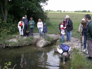
eroded the bank. While the younger members worked
this out with Ann's help, Adrian took the opportunity
to search for aquatic specimens (see picture above left).
Later, on the river's edge, Ann used the local
geological map to explain the geology of the
river. The map showed how deposits of clay, sand,
and gravel indicated the locations of earlier
rivers. This was to be confirmed, on the ground
in the afternoon, in the geomorphology west of
Lullingstone Castle.
During the return Adrian found a clump of
Non-stinging Nettle, Urtica galeopsifolia
which is quite rare. The grid reference was
noted, using a GPS, for reporting the find to
Eric Philp.
At lunch time many members stayed at Horton Kirby
to enjoy the village fete in the afternoon. The
rest of us drove to Lullingstone Country Park.
Return to Top
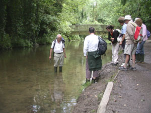
After lunch we walked the river bank northwards
to Lullingstone Castle, giving Adrian further
opportunities to search for aquatic fauna (see
picture above right).
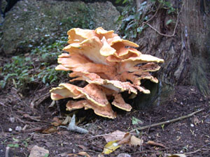
From Lullingstone Castle we headed up the hill
towards the golf course. We passed a depression
surrounded by Yew trees, where we saw toads and a
fine fungus (see pictures below) and walked
through meadows filled with wild flowers before
descending again to the car park of the
Lullingstone Country Park where we took advantage
of the refreshment facilities before calling it a
day.
This is a lovely part of the countryside for a
walk, with plenty of interest for all ages.
For anyone wishing to make detailed study of the
area it is recommended that they arm themselves
with the following documentation:-
-
British Geological Survey, England and Wales
Sheet 271, Dartford, 1:50,000 Series.
-
Darent Valley Path Guide, Published by Kent
County Council, 2007.
ISBN: 1-901-509-77X, Price £4.99,
available from the KCC on-line shop.
-
Ordnance Survey Explorer Map Sheet 162,
Greenwich and Gravesend. 1:25,000 Series.
Special thanks are due to Ann Barrett for
organising and leading the walk; to Anne Padfield
and Nick Baker for help in the planning; to Anne
Padfield for geological expertise during the walk
and to Adrian Rundle who, as always, was a mine
of information on all wildlife matters.
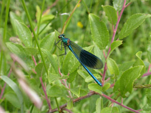
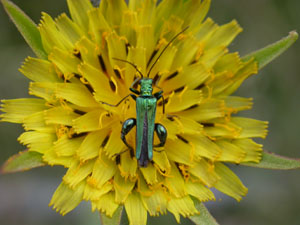
Some pictures of the wildlife seen on the walks,
taken by Stephen Taylor, are shown below:-
Return to Top
|
|
Male Banded Demoiselle, Calopteryx
splendens, at Lullingstone Country
Park
�
|
A False Oil Beetle,Oedemera nobilis,
at Lullingstone Country Park
�
|
|
|
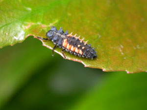
Larva of the Harlequin Ladybird,
Harmonia axyridis, Lullingstone
Country Park
�
|
A splendid Fungus, among yew trees to the
west of Lullingstone Castle
�
|
Return to Top
Access and Safety
Horton Kirby is a lovely, small village 1.5 Km
north of the A20 and 3 Km west of junction 3 of
the M25. There is a small car park at the sports
ground west of the river Darent. The riverside
walk, southwards from the sports ground, along
the west bank and returning via the east bank is
about 1.5 - 2 Km and is on public footpaths.
Lullingstone Country Park is 1.5 Km south of
Eynsford on the A225. After leaving Eynsford the
road passes under a railway line; the Country
Park is reached via a signposted right fork after
0.5Km.
The riverside walk to Lullingstone Castle and the
return via the golf course are on public
footpaths.
Note:The walks are suitable for all
abilities. However, riverbanks can be very
slippery. Rivers and streams, however shallow and
slow flowing, can always present a hazard. Young
people should be carefully supervised at all
times.