For anyone interested in geology and travelling
in South Shropshire, the geology trails in
Mortimer Forest are well worth a visit
The Trails lie to the west of Ludlow, in
Shropshire, adjacent to a minor road between
Ludlow and Wigmore.
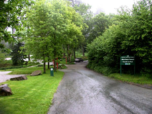
The best starting point for exploring the trails
is the High Vinnalls car park (see 'Access and
Safety' below). The entrance to the car park is
shown left.
The rocks in the Ludlow area date from the
Silurian Period, first defined by Sir Roderick
Murchison in 1835 and named after the Silures a
celtic tribe that inhabited the area of Wales
where he conducted his studies. The rocks consist
mostly of limestone and shale and were deposited
between 410 and 440 million years ago in a
shallow sea that was slowly closing and was to
disappear completely by the end of the period.
The Silurian period is divided into four series,
Llandovery (oldest), Wenlock, Ludlow and Pridoli
(youngest) and these trails have exposures in all
except the Llandovery series.
Some of the sites are protected. There are two
separate trails each with its own excellent trail
guide. Both guides give information on permitted
collecting. To make the most of these trails it
is recommended that visitors equip themselves
with a copy of the guides, especially if their
interest is in fossils rather rhan geology.
Maps
-
O.S. Landranger Series, 1:50,000, Map 137
(Ludlow and Wenlock Edge).
-
O.S. Explorer Series, 1:25,000, Map 203
(Ludlow).
-
British Geological Survey, 1:50,000 Series
Maps, England and Wales Sheet 181, Ludlow
-
British Geological Survey, 1:25,000 Classical
Areas Maps, No. 16 Leintwardine, Ludlow.
Return to Top
Trail Guides
-
The 'Mortimer Forest Geology Trail'
(published in 2000 by Scenesetters for the
Forestry Commission)
This trail was created by the Nature
Conservatory Council (now Natural England) and
the Forestry Commission in 1977 to recognise
important research in the area in the 1960s
that had redefined the Ludlow Series. The
studies created two new geological time stages
that are now accepted worldwide, the Gorstian
and the Ludfordian.
Copies of this trail guide may be obtained
locally from the 'Secret Hills Discovery
Centre' at Craven Arms. The centre usually has
a good range of local geology books, guides and
maps and also serves meals!
The trail guide describes 13 locations
(identified on the ground as 'stops'). Except
for locations 4 and 5, all are small quarries
adjacent to a 4Km stretch of road with no
footpath and care must taken when walking
between stops.
-
Geologists' Association Guide No. 27: The
Geology of South Shropshire by M. Allbutt,
J. Moseley, C. Rayner & P. Toghill, 3rd Edition
2002.
Itinery 5: The Standard Ludlovian section of
Mortimer Forest
-
gives detailed geological information for the
area and includes a geology trail,
coincidentally also of 13 locations. Unlike the
trail above this circular 10 Km trail lies
wholly within Mortimer Forest on roads free
from traffic (except for occasional Forestry
Commission vehicles) and therefore can be
safely followed either on foot or by bicycle.
The pictures and descriptions below are for the
shorter Forestry Commission trail.
Return to Top
Mortimer Forest Geology Trail
Turn left out of the car park and walk towards
Wigmore.
Location 1: The first location is about
300 metres down the road on the right hand side.
It is a small quarry standing back from the road
and may be identified by 'Mortimer Forest
Geological Trail Stop 1' on a wooden post in the
grass verge. If you reach the bottom of the slope
and Pitch Cottage on your right you have come
about 50 metres too far!
Here one can see alternating layers of limestone
and mudstone from the Much Wenlock Limestone
Formation of the Wenlock Series. One may find a
few Brachiopods but fossils are scarce. The
mudstone layers suggest repeated silty incursions
that are unsuitable habitat for filter feeding
organisms such as corals.
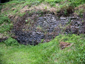
Location 2: About 60 metres up the hill
from stop 1 is another small quarry that shows
hard nodular limestone from the uppermost Much
Wenlock Limestone Formation. This is stop 2.
Fossils are only freed from the nodular limestone
by natural weathering so fossils such as
brachiopod shells are most likely to be seen in
the rock surface or washed out in the scree at
the foot of the rock face.
Return to Top
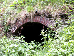
A few metres above stop 2 may be seen the remains
of an old lime kiln (see picture, above right).
This presumably processed limestone from the
quarries to produce quicklime for agricultural or
building purposes.
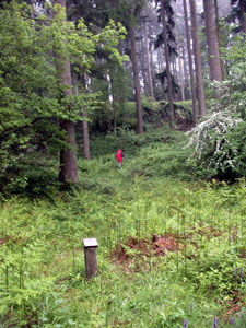
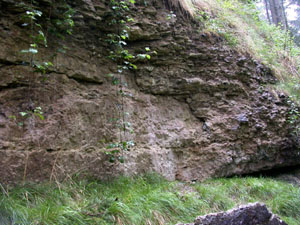
Location 3: Location 3 is a few metres
above location 2 on the other side of the road.
It is approached through a small plantation of
Douglas Firs. The quarry is just visible in the
picture on the left, at the base of the distant
trees beyond the figure in red.
Here two visible metres of hard nodular Wenlock
limestone are over lain by well-bedded siltstone
of the lower Elton Formation, Ludlow Series.
Scientifically, this is probably the most
important site on the trail.
The boundary between the Lower Elton bed
siltstone and the Wenlock limestone is the
International Stratotype Boundary between the
Wenlock Series and the Ludlow Series.
Do not hammer or scramble across this
boundary on the quarry face
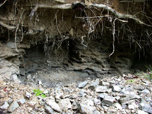
Location 4: Return to the Vinnalls car
park. Take the wide forestry road climbing up
beyond the vehicle barrier. After about 250
metres, at the top of the rise, another wide
forestry track descends on the left. Follow this
white-waymarked forestry track for 700 metres.
Just beyond a pond on the left, at the bottom of
a descent, a stream crosses the track. Here, to
the left of the track, the Forestry Commission
has excavated a section of the stream bank. This
is location 4 (there is no visible post with the
usual 'Stop n' label).
Academically, this site is valuable for
graptolites that are important for the
international correlation of sites. However, it
is also a popular hunting ground for the
Trilobite Dalmanites, though mostly only
fragments are found.
One can see in the picture below, taken in May
2008, how the site has been plundered by fossil
hunters.
Pictures of the the first four exposures on the
trail are shown below:-
Return to Top
|
|
Stop 1: Much Wenlock Limestone Formation -
alternating layers of limestone and
mudstone
|
Stop 2: Uppermost Much Wenlock Limestone
Formation - hard nodular limestone
|
|
|
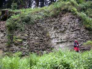
Stop 3: Much Wenlock Limestone Formation -
Wenlock Series and Lower Elton
Formation
|
Stop 4: Middle Elton Formation - Dark
mudstones with lighter grey calcareous
bands
|
Return to Top
Other Locations
The remaining locations, 5 to 13, are spread
along 4Km of the road between High Vinnalls car
park and Ludford Corner. They cover the whole of
the Ludlow Series and the base of the Pridoli
Series and are briefly summarised below:-
-
Location 5: Upper Elton Formation
-
Location 6: Lower Bringewood Formation
This site is at Gorsty which gives its name to
the Gorstian Stage of the Ludlow Series.
-
Location 7: Upper Bringewood Formation
-
Location 8: Lower Leintwardine Formation
-
Location 9: Lower Leintwardine Formation
-
Location 10: Upper Leintwardine Formation
-
Location 11: Upper Leintwardine Formation
-
Location 12: Lower Whitcliffe Formation
-
Location 13: Upper Whitcliffe Formation
Location 13, the world-famous Ludlow Bone Bed
site, also carries a plaque to commemorate the
150th Anniversary of Murchison's Silurian System.
Access and Safety
From the town square in Ludlow head south, down
hill, towards the river. Immediately after
crossing Ludford bridge, and before the rise,
turn sharp right along a road marked "Forestry
Commission" and signposted 'Wigmore'.
After a short distance, at the top of a rise, the
Forestry Commission Offices can be seen on the
left. After about 4Km (2.5 miles), turn left into
the High Vinnalls car park. The area is owned by
the Forestry Commission, has free public access,
and is the starting point for both trails.
Notes:
-
All but two of the thirteen 'stops' described
in the 'Mortimer Forest Geology Trail' are
excavations at the side of the road from Ludlow
to Wigmore. There is no footpath, so traffic
poses a significant threat. Extreme care is
needed when walking between stops.
-
Except when expressly permitted, do not hammer
on rockfaces. Some faces have been undermined
so that hammering can be dangerous. Also, some
of the locations have important structural
features that can be destroyed by hammering.
Return to Top